
Can you remember from earlier blogs what the name of the other boat was? There is an 800-acre living-history museum that we walked through that showed how the first settlers lived. There were tons of school children going through the museum with their teachers and they got to do a lot of the work the settlers had to do for food and protection. Most of this was learned from the Indians, so there are many Indian artifacts they could look at and play with. Because we were only staying on land for a few hours to walk through the museum and see the "Dove", they let us tie up to a dock near the museum. When we got back to the boat, we anchored a few yards away for the evening to sleep.
The next morning, we headed out of the Potomac River and back into the Chesapeake Bay. During the day, Tammy was listening to the marine weather forecast and realized we were going to be heading into some bad weather in a few days, so we needed to change our plans and gitty-up to get closer to our next destination, James River. The James River is where we are going to meet up with Doug's family. They live in Virginia, so our first stop was at a small bay that we stayed at when we brought Gypsies up to Maine earlier this year. It's called Fishing Bay, which is a little ways up the Piankatank River off the Chesapeake Bay. Again, we know it's a good spot to anchor and be protected from the heavy winds because when we got there only 2 boats were
in the bay; by nightfall there were about 12.
We left early morning so we could make it inside Hampton Roads just above the James River. We had another gorgeous sunrise as we left. Every one seems prettier than the last.

We made reservations at the town docks for one overnight visit. We made it to our slip at Hampton Roads early enough for us to get off and walk around town for a bit. There wasn't much to see where we were, but it was nice to stretch our legs. Again, early the next morning we set out of Hampton Roads and up the James River to our destination, Kingsmill Marina in Williamsburg, Virginia. My husband (Uncle John) has been in Manchester, New Hampshire for a few weeks for business and was flying into Richmond, Virginia. Doug's fabulous sister Dale and her family let us borrow a car for a few days, so I was able to pick-up John at the airport and bring him back home to the boat, so we couldn't be a day late. As we made our turn towards the James River we got to go over an underground (or underwater) tunnel. We could see on one side of land the cars going into the tunnel
then coming out on the other side of the tunnel running beneath us. Very cool!
When we turned into Kingsmill Marina there were may birds huddling to stay warm on the protective jetty of the marina.

We ended up staying a few days at Kingsmill Marina because of bad weather and high seas. Besides having a grand time meeting all of Doug's wonderful family, Williamsburg is a great place to spend a few days.
Part of Williamsburg, Virginia is a living museum as to what life was like in a colonial village. In American history, the events that occurred in Williamsburg were pivotal, as Virginians evolved from being subjects of a distant monarch (Great Britain) to citizens of a self-governing republic. These events lead the colonies to declare that we were no longer under British rule but the free independent United States of America. As we went through Colonial Williamsburg, we got to see horse-drawn carriages,

John stuck in and old "Stock" where they use to punish the people who did not obey the law

and lots of kids running in the streets doing their own reenactment of the times.

We also went through The College of William and Mary, Doug's Alma Mater. This is the second-oldest institution of higher education built in the United States. Can you tell me what the first one is? It was built in Cambridge, Massachusetts. William and Mary is where President Jefferson, our third President of the United States went to college when he was only 16 years of age.

The Wren Building shown below, is where he lived and did most of his studies.

Two other Preidents of our nation went to school here also. Can you name them?
The next day we went to Yorktown, Virginia. This was the site of the final battle of the American Revolution where on October 19, 1781, General Cornwallis surrendered his British Army to the combined American-French forces under Generals Washington and Rochambeau. Yorktown also figured prominently in the Civil War, serving as a major port to supply both northern and southern towns, depending on who held Yorktown at the time. We started out watching a 16 minute documentary, then went through the museum.

We spent most of our day driving and walking through the battlefields.

We got to see where the cannons where set-up,

trenches were dug, defensive barricades were established

and where the actual surrender took place. As we walked up to the Moore House (where the terms of surrender were negotiated) we saw a family of deer feeding and playing in the fields along the river.

Well, it was time to leave Williamsburg and head to our next destination, Portsmouth, Virginia. We headed out of the James River, and across the bay into the "Intracoastal Waterway". The Intracoastal Waterway is a 3,000-mile waterway along the Atlantic and Gulf coasts of the United States. Some lengths consist of natural inlets, salt-water rivers, bays, and sounds; others are man-made canals. Many boaters heading south for the winter use this protective waterway. We could travel "outside" (along the eastern seaboard on the Atlantic Ocean) but there is much more to see and the waters are much calmer on the "ICW". On our trip we got a visit in the sky from Doug's nephew Larkin when he flew over us in his Blackhawk Helicopter. We took pictures of him and he took pictures of us. That was very cool!

When we tied up at the dock in Portmouth, Virginia, Uncle John cooked up a bunch of shrimp Doug's nephew Luke brought us as a gift from a friend of his. They still had the heads on them so we had to pull them off before we could cook them. The marina had a bunch of fresh herbs from a garden they have and let us take what we wanted for our trip. That was very nice! We used a bunch of Rosemary on the shrimp on the grill, very yummy! The next morning we headed down the ICW (Intracoastal Waterway). The first part of the trip was full of many low bridges we had to wait to open for us to pass.

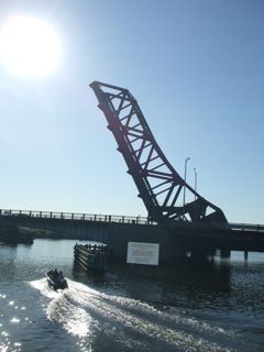
We got to see many different kinds of drawbridges. The type of movable bridge that most people think of as a draw bridge is similar to those that spanned medieval castle moats.
Also in this part of our trip we went through a "Canal lock", a stretch of water enclosed by gates, one at each end, built into a canal or river for the purpose of raising or lowering a vessel from one water level to another. When the ship is to be raised to a higher level, it enters the lock and a gate is closed behind it. Water is let into the lock until its level equals that of the water ahead.

The forward gate is then opened, and the ship progresses on the higher level. The procedure is reversed when the vessel is to pass from a higher to a lower level. As many locks as necessary are used in a given waterway. Among well-known locks are those of the Panama Canal. Can you tell me how many locks are needed for the Panama Canal? We ended our very exciting day anchoring in Black Water Creek 30 miles down the ICW. 30 down, many more miles to go. Until then...may your nose and toes always be warm.

No comments:
Post a Comment